
About Shrewsbury Vermont Snowmobile Trails and Maps
Topics on this page:
- General Trail Information
- Trail closures
- Parking Areas
- Historic Buildings
- Public Lands
- Sno-Birds Maps
- Maps of Shrewsbury Area on the Web
General Trail Information
The Shrewsbury Sno-Birds maintain 36 miles of trail. The southern most point in our area is on the Old CCC Road of North Shrewsbury. The trail system extends north to Route 4 in Mendon. The two main trails that pass through our territory are VAST Corridors 4 and 7. In our area they are the same trail which we refer to as “4&7.” South of the Sno-Birds system, 4 diverges to the east while 7 continues south through the Green Mountain Snow Fliers trail system. North of the Sno-Bird system 4&7 diverge in the Chittenden Dammers trail system. Our new 407 trail is a great North-South alternative to 4&7 and follows a route west of the main trail. Likewise, 4A is an alternative to 4 as it departs from 4&7 taking a higher elevation route before joining 4 again.
^ scroll up to page section list ^
Trail Closures
- All trails open!
^ scroll up to page section list ^
Parking Areas

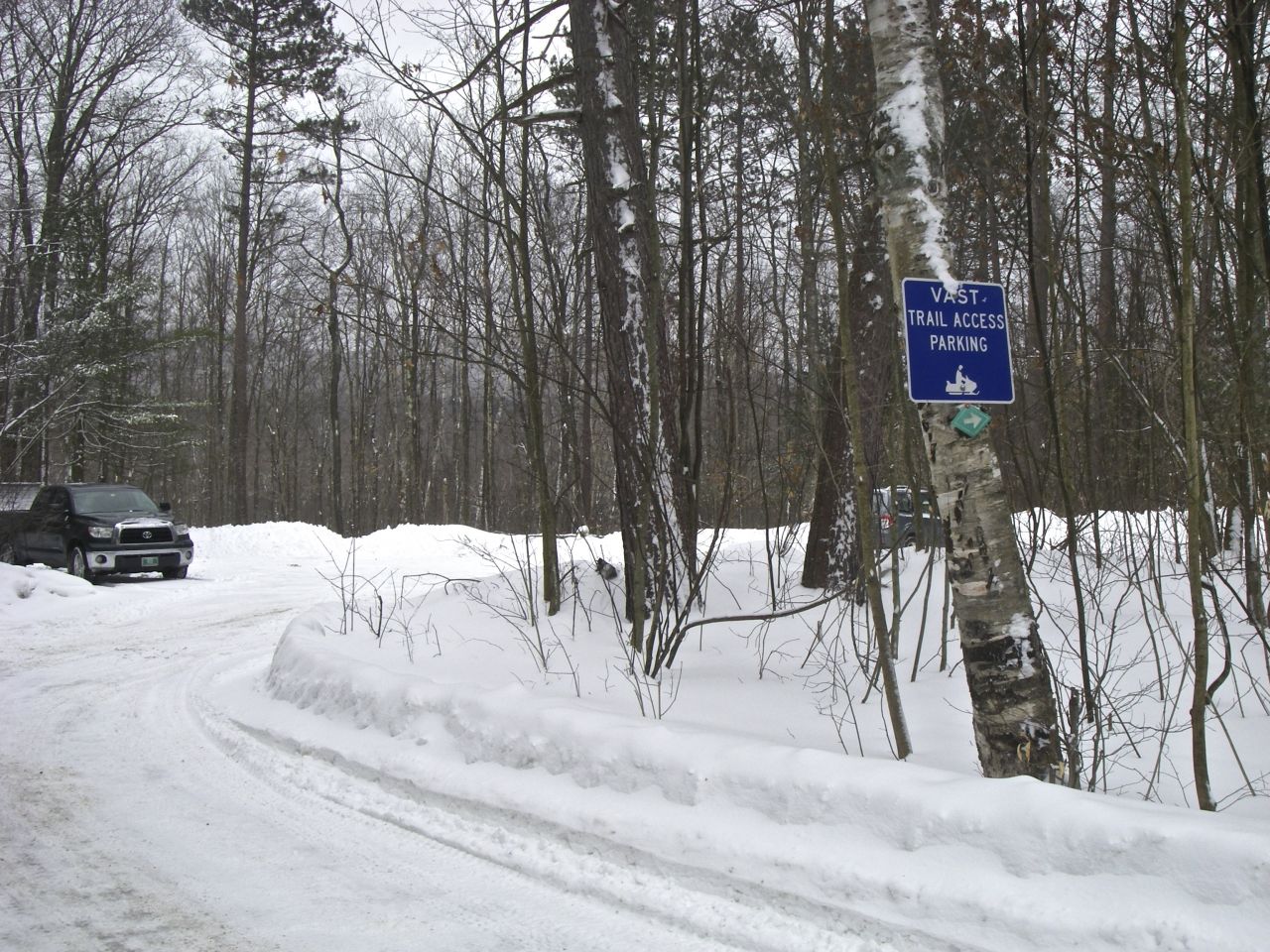
Grooming Shed & VAST Parking Area
- Upper Cold River Road – VAST Parking – This area is reached almost entirely on paved roads to North Shrewsbury and then just a quarter-mile of Upper Cold River Road an a dirt road to the parking lot. An upgraded feed trail now provides access to corridor trails without riding on plowed roads. See the trail work entries in our blog.
Notch Road Vast Parking Area
- Notch Road – VAST Parking – Accessed from Killington Avenue and Townline road, Notch Road is paved through the notch and continues as a dirt road to the parking lot.
- Route 4 – VAST Parking – As of 2013 an official VAST parking lot was established just west of Snow Angel Restaurant in Mendon. Park with the assumption the lot will fill as this lot provides access to the main corridor trail 4&7. Also note that the Chittenden Dam parking area is closed to snowmobilers so riders who used to use it may use this Route 4 lot. See this post on the Chittenden Dammers site for more information.
- Cortina Inn Guest Parking – Private – Cortina Inn guests have convenient access to 4&7 right from the guest parking lot. Inn guests only!
^ scroll up to page section list ^
Historic Buildings
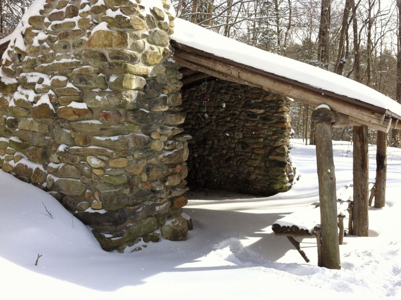
Governor Clement Shelter
Two historic buildings stand proudly along our trails. Governor Clement Shelter was built in 1929, and is located near the southern junction of trails 407 and 4&7. It is a nice stone, open lean-to that has a fire-place making it an ideal lunch spot. It is one of the oldest shelters on both the Appalachian and Long Trails. It has a history of being used as a party place and being left a mess for legitimate uses like snowmobile picnics. Recent renovations have restored it to excellent condition structurally.
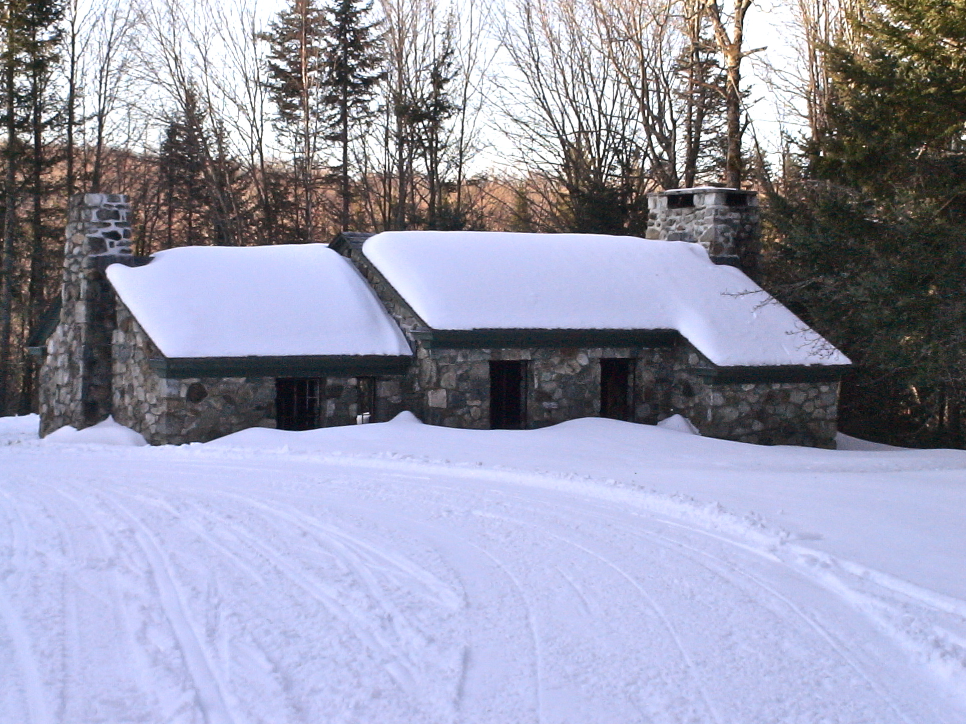
Stone House
New gates on the roads accessing it are closed in summer months to protect it from misuse. Please help us show gratitude for these improvements and the privilege VAST members have in using the shelter by keeping it clean.
The other old building to see is the Stone House off the Old CCC Road. It was built by the CCC in the 1930’s and was the original Coolidge State Park headquarters before it relocated to its current location in Plymouth off Route 100A. Check out these unique shelters! Use them and help us take care of them by taking home your trash and leaving them cleaner than you found them.
^ scroll up to page section list ^
Public Lands
Our trails traverse three different multi-use public lands. They are listed here and linked to more information.
- Coolidge State Forest
- Aitken State Forest
- Rutland City Forest
Though no documents specifically about the Rutland City Forest could be found on the web, Coolidge West Management Unit contains detailed information about all three public lands, their history and management plans. The northern extreme of Corridor 4&7, passes through the Rutland City Watershed. To say this north/south link to the Chittenden Dammers system to the north is important to our club and the VAST trail system is a huge understatement, though for over 20 years permission for this 6 mile trail section was denied to snowmobiling. Twenty years of planning and negotiations finally reopened the trail to us. Determined Sno-Birds Members made it happen! Read more about the process in this Rutland Herald article.
^ scroll up to page section list ^
Maps of Shrewsbury Sno-Birds Area
Sno-Birds Maps
- Google Earth and Our Network link – Since it is very customizable, our trails have been configured to be viewed on Google Earth, a program that runs on your computer. If you don’t already have it you can download it for free here. Using Google Earth to map our trail system gave us the option to color code trails and landmarks. We’ve added a legend to the map so you will know what the colors mean.To keep your Google Earth version of Sno-Birds Trail System up to date, we recommend following these steps:
- Copy this highlighted link: http://db.tt/lGptb1sO
- With the link copied to your clipboard, open Google Earth and from the “Add” menu choose “Network Link.” A dialog box opens and in the “Link:” field you should paste the link from your clipboard.
Save and you are DONE! Now when we update the GPS data for the map, your version will update on your Google Earth too! Congratulations, you can view the Sno-Birds trails in 3D. Double clicking anything in the sidebar locates that item in the center of the map and zoomed to fill the map. For a sample of what Google Earth can do, open the Snobird trail sections folder and double-click the first item on the list called Tour of Trail System. This is a tour that will fly you around the trail system, zooming in on landmarks and zooming out at times to give an overview of a section of trail. It runs for about 8 minutes. You can fly around on your own as well and revisit the landmarks by clicking them so you can read the information about each one. Use the controls in the upper right to change direction, tilt, fly in any direction or zoom. Experiment! No worries of crashing.
You can fly anywhere over the earth. Visit your favorite vacation spots or your home. Use the search field for any location and be whisked off to the spot in seconds! Something GPS users will enjoy is tracking themselves while snowmobiling and saving the track to their computer as a KML or KMZ file. Opening either file type will add the track to Google Earth superimposed over the trail system. You can send the track to someone else to show them were you went. GPS tracking is available to iPhone 3G and above as well as other smart phones. There are several apps but the most reliable we have found is called Motion X GPS.
- Panoramio – Ever wonder how those little photo icons got into your Google Earth map? You can turn them on or off with the Photos check box in Google Earth’s Layers but where do they come from? Enter Panoramio, companion photo place sharing for Google Earth. It is a photo sharing site where approved photos are displayed right in Google Earth where all the world can see them.Photosmustbelocated on a map so uploading GPS tagged photos are located automatically but you can also locate your non-GPS tagged photo on a map yourself, manually.
For photos to be approved, they must not be of people or machines or building interiors as the site is about documenting places. Here are some examples: Pictures of the Stone House or Clement Shelter would be approved if there were no people in them. Likewise a photo of a trail would be approved if there were no snowmobiles or people. It is very easy to sign up and upload your photos. There is a delay period before photos are approved and will display in Google Earth so please be patient. Here are some sample photos on Panoramio in Shrewsbury. Don’t forget you can upload your pictures of sleds and people to our SmugMug site.
^ scroll up to page section list ^
Maps of Shrewsbury Area on the Web
These maps show the diverse recreational uses the public lands are managed for and other trails besides the Sno-Birds trail system. The winter map is most interesting as it shows our trails in relation to others.