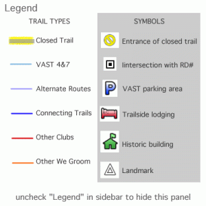
You may remember the Google Earth Network Link I created last season. It is still working so all you have to do is launch the Google Earth program on your computer and it will automatically update with the latest changes in the trail map I’ve made. Two trails are no longer closed which is updated on the map and I have added a legend so you can see how the trails are color coded. Just uncheck “Legend” in your Google Earth sidebar to make it disappear.
The following is a Google Map version of the data but I encourage you to view the data in Google Earth where it provides a 3D way of viewing the trails in the contours of the hills. You can fly over the trails! If you didn’t load the Network Link into Google Earth on your computer last season, the directions on how to do it are included on this page. Links to both items are available under the “Maps” heading in the left sidebar on every page. Please write your comments below as to how the trail data works for you in Google Earth or Google Maps.
View Snobird trail sections in a larger map


1 comment
Author
By the way, the legend is not visible in Google Maps but floats above the hills in Google Earth!