
Carpenter and website developer. Amateur photographer.
Cliff Dutton
Author's posts
To Subscribers Via Email…


For those who perviously were subscribed via email to receive new posts to the Sno-Birds blog, you will need to re-subscribe. Unfortunately we lost our mailing list so please use the handy “Subscribe Via Email” near the top of our blog pages to re-enter your email address. Also pass the word on to any of …
Shrewsbury Sno-Birds Trails Now Available on Google Earth
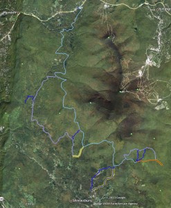
It’s true you can view our EveryTrail map right in your browser but don’t stop there. We have created a color coded trail map especially for Google Earth viewing with placemarks, photos and even showing the closed trails so you won’t plan your trip only to find the trail you wanted to use is closed. …
Wildlife Gallery
I just wanted to make sure everyone got to see this new gallery in SmugMug. Roy wanted a wildlife gallery so here it is. I hope the photographers will claim their work. Nice work with the trail cam! Is the night shot a fisher cat?
Photo Trail Report!
Thank you to the person who posted these photos! They were taken on March 14, 2013 obviously to show how much snow is still on the trails so I have posted them here to serve as a trail report. The photographer can post locations in the comments on the photos in the SmugMug Gallery.
Trek to Track Connector Trail
This was a 10 mile trip on skis and foot to track just the 1 mile of connector trail between the two corridors 4 & 7 and 407 just North of Clement Shelter. Also Thanks to Gary Arthur for noticing that some road tracked in this trip and on the original track from the ride …
Section 3 GPS Track Fix
This trip ended up being longer than I expected because I skied to the parking lot on the access trail. See the track below. The section of 407 is nearly a straight line so not a lot of change from the straight line that represented the missing GPS info. Marking the junction of the parking …
Second Fix to GPS Trail Map
Another short ski trip on the trail running my GPS tracker. Some serious hills in this section! I’ve added this route correction to the Sno-Birds GPS Trail Map on EveryTrail. Formerly this section was represented by a straight line connecting Gate #2 with my northern most point. As you can see below, the trail is …
Fixed 1st Section of GPS Map
I was out on Wheelerville as well yesterday and saw the bent gate. I was there to track a piece of trail that the GPS tracker missed on the Groomer trip I made with Roy. I started at the Bucklin Trail and headed south from the gate. I only had to follow it for 1.5 …
Fatal Snowmobile Crash – Pittsfield
Some disturbing news in a post by the Chittenden Dammers. Maybe someone can add more details.
Additions and Changes to the Website
Photo Sharing
Thank you to all photo uploaders! You are making our site grow with your photos. Check out the updated Photo Sharing Info page. More in-depth upload instructions and more about what can be done with your photos on SmugMug. If something on the page is unclear or incorrect please contact me with some …
Recent Comments